 Follow Us on Google Discover
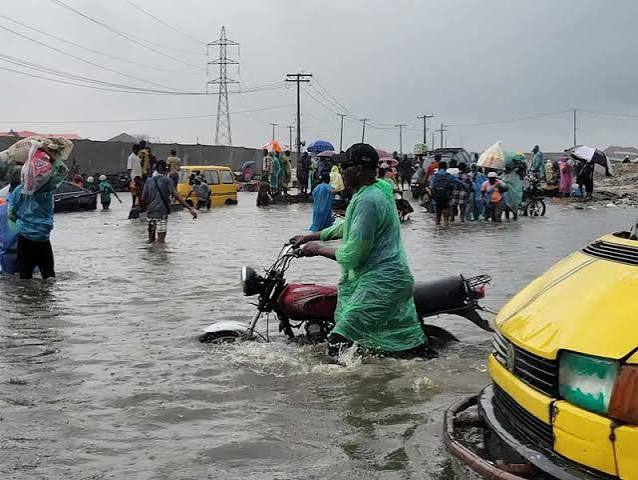
On a rain-soaked morning in Lagos, residents of Kunsela Road in Ikate waded through knee-deep floodwater as they went about their day.
Motorists cautiously steered their vehicles through the murky water, hoping their engines would not stall before reaching dry ground.
Several kilometres away in Shogunle, Oshodi, Osila Obarijima, looking through the window of her first-floor apartment, watched muddy floodwater carrying refuse and debris rush through the residential street below.
The water rose above the tyres of parked vehicles as residents living on the ground floor and in bungalows hurried to move belongings to safety, fearing they would be swept away by the fast-flowing current. In some homes, floodwater had already found its way indoors.
Also Read
The scenes were repeated across parts of Gbagada, Ikorodu Road, and Ajiran during the last days of June and the first days of July, as days of intense rainfall submerged roads, disrupted businesses and left many residents counting their losses across one of Africa’s largest cities.
For many Lagos residents, flooding has become an all-too-familiar consequence of the rainy season. Yet the latest incidents have revived a familiar question: Why does Lagos continue to flood? The Lagos State Government points to a mix of coastal geography, climate change and urban development, but experts who spoke with Nairametrics say the floods exposed deeper planning, environmental and infrastructure challenges.
What they are saying
According to the experts, the flooding points to decades of planning, environmental, and infrastructure choices that have altered how Lagos absorbs and drains stormwater.
Urban planner, Tpl. Niyi Aderohunmu, said the replacement of wetlands and mangroves with residential and commercial developments has significantly reduced Lagos’ natural capacity to absorb stormwater. He explained that wetlands once functioned as natural “sponges” that absorbed rainfall and released it gradually, but have now largely been replaced by impervious concrete surfaces that generate faster and higher volumes of runoff.
- “From an urban planning perspective, the replacement of Lagos’ wetlands and mangroves with residential and commercial developments has been one of the most significant drivers of the city’s increasing flood risk. While climate change and intense rainfall contribute, decades of land-use changes have greatly reduced the city’s natural capacity to absorb and manage stormwater,” Aderohunmu told Nairametrics.
According to him, this shift has also disrupted natural drainage channels and weakened coastal buffers, particularly in low-lying areas such as the Lekki corridor, where tidal conditions now worsen flooding during heavy rainfall.
Geographer, Abeeb Babajide Ajagbe, also described wetlands and mangroves as “natural flood infrastructure,” noting that their removal has left Lagos with little capacity to absorb rainfall.
He argued that beyond environmental loss, the issue reflects governance failures, pointing to planning decisions, approvals, and enforcement gaps that have enabled development in sensitive flood zones.
- “Every building that sits on the Lekki corridor had a permit or should have a permit and a transaction must have occurred. The destruction of natural flood infrastructure is the cumulative result of planning decisions that prioritised short-term development revenue over long-term flood resilience,” he explained.
Environmental resource management expert, Gbenga Oloniniran, echoed this view, saying unregulated urban expansion has removed natural barriers that previously reduced flood impact.
He said the absence of wetlands and mangroves has made low-lying areas more susceptible to fast-moving surface runoff during prolonged rainfall.
However, independent researcher, Tonami Playman, argued that Lagos’ flooding cannot be fully explained by environmental change alone. He said the core challenge is the absence of large-scale water storage infrastructure capable of buffering excess rainfall during extreme weather events.
- “The flooding in Lagos can be attributed to the coastal geography, urbanization, loss of wetlands, but to attribute it to climate change is an easy way to escape responsibility. The rainfall data for Lagos is not historically unusual.
- “The most critical cause is lack of sufficient flood mitigation infrastructure. Just building drainage is not enough to mitigate flash floods. You need water storage infrastructure to act as a buffer,” Playman argued.
- He added, “Cities are not naturally occurring, but arise from artificially reshaping a natural landscape, so relying on natural buffers like wetlands to protect an artificial system is rather naive.”
According to him, even well-maintained drainage systems are insufficient without reservoirs, tunnels and storage systems similar to those used in cities such as Tokyo, Chicago and Kuala Lumpur. He noted that Lagos’ current approach remains heavily focused on drainage expansion rather than long-term flood storage infrastructure.
Lagos govt’s explanation of the flooding situation
The Lagos State Government says the recent flooding reflects a combination of the city’s natural geography, climate change and long-term environmental changes that have reduced its capacity to cope with heavy rainfall. It also situates the issue within a regional context, noting that coastal cities such as Accra, Lomé and parts of Côte d’Ivoire have also experienced similar flooding, suggesting the challenge is not unique to Lagos.
Speaking during a Nairametrics X Space titled “Flooding in Lagos: Beyond the Rain. What Must Change,” the Commissioner for Environment and Water Resources, Tokunbo Wahab, said Lagos’ coastal location makes flooding difficult to avoid.
He noted that about one-third of the state consists of lagoons, rivers, swamps and streams, while some areas, particularly the Lagos Island corridor, lie below sea level. Stormwater, he said, naturally drains into these water bodies, which serve as the city’s primary drainage system during heavy rainfall.
Wahab said rapid urbanisation over the past two to three decades has worsened flooding, as wetlands and mangroves that once absorbed excess rainwater have been replaced by residential and commercial developments, especially along the Lekki corridor, weakening natural flood buffers.
He also pointed to illegal land reclamation in areas such as Ajiran, Agungi, Ikota and the Chevron corridor, where parts of the lagoon were allegedly reclaimed without approval, narrowing drainage paths and worsening flooding in surrounding communities.
Another factor he highlighted is tidal locking, where heavy rainfall coincides with high sea levels, temporarily preventing stormwater from draining into the lagoons and Atlantic Ocean, leaving water trapped within the city until tides recede.
Responding to forecasts of unusually high rainfall in 2026, Wahab said the state has issued flood advisories, intensified desilting through the Emergency Flood Abatement Gang (EFAG), expanded drainage infrastructure and cleared blocked waterways. He added that these measures are meant to reduce the impact of flooding rather than eliminate it.
What the experts recommend
Experts who spoke to Nairametrics agreed that Lagos’ flood challenge requires a combination of planning reform, infrastructure investment, and stronger environmental protection, though they differed on emphasis.
Tpl. Aderohunmu said Lagos needs a fundamental shift away from reliance on drainage infrastructure alone, arguing for a “blue-green planning” approach that integrates engineering solutions with ecosystem protection.
- He said wetlands, floodplains and drainage corridors must be legally protected and restored, noting that “we can’t stop the rain, and we can’t change Lagos’ coastal geography, but we can stop building on the systems that naturally manage water.”
He also called for stronger development control backed by hydrological assessments and stricter enforcement to ensure that approved plans are followed on ground.
For Ajagbe, a geographer focused on environmental risk and governance, the priority is preserving remaining natural buffers while reforming land-use decisions that continue to expose new areas to flooding.
- He said Lagos must legally protect wetlands and mangrove corridors still intact, describing them as “functioning flood infrastructure.” He also advocated integrating nature-based solutions such as green roofs, permeable pavements and urban green corridors into already built-up areas to reduce runoff.
- Ajagbe further called for stricter environmental review of new developments, stressing that no project should be approved on flood-prone or ecologically sensitive land without independent assessment, adding that the “expanding flood boundary is partly a planning failure.”
On infrastructure, Oloniniran said Lagos must go beyond drainage expansion and invest in active flood-control systems.
He recommended floodgates and large-capacity pumping stations in low-lying and island areas to manage seawater intrusion and redirect excess stormwater when natural drainage is overwhelmed. He also stressed the need for temporary evacuation shelters to house residents immediately after flood alerts, noting that such facilities are currently lacking.
Beyond infrastructure, he highlighted waste management as a critical gap, calling for more effective citywide waste collection systems, alongside stronger public sensitisation. He also supported tree planting and wetland preservation as complementary nature-based interventions.
Independent researcher Playman, however, said the core issue is not only planning or ecosystems but the absence of large-scale flood storage infrastructure.
He argued that Lagos’ current response measures, while useful, are insufficient, stressing that long-term resilience depends on building systems that can temporarily store excess stormwater during peak rainfall. He also called for a comprehensive mapping of the city’s elevation and drainage structure to guide phased infrastructure development.
What other cities reveal about flood management
While Lagos continues to experience recurring flooding, similar events have also been recorded in other West African coastal cities, including Accra in Ghana and Lomé in Togo. Independent researcher Playman said these cases reflect a shared structural weakness rather than offering solutions.
He argued that the core problem across Lagos, Accra and Lomé is insufficient flood mitigation infrastructure, stressing that even with fully cleared drainage channels, the cities would still flood due to limited storage capacity.
According to him, West African cities do not provide a reliable blueprint for Lagos, as none have developed systems capable of managing large-scale flash flooding. He said Lagos should instead look to global cities that have invested heavily in engineered flood-control infrastructure.
Playman cited Kuala Lumpur’s SMART tunnel, a $515 million dual-purpose road and stormwater system designed to temporarily store floodwater during heavy rainfall, with a capacity of about 3 million cubic metres. He noted that even this system is supported by holding ponds and additional storage reservoirs.
He also referenced Chicago’s $3 billion Tunnel and Reservoir Plan, launched in the 1970s and scheduled for completion in 2032, which has a storage capacity of about 8.7 million cubic metres for the portion completed so far.
In Tokyo, he pointed to the G-Cans underground stormwater system, completed in 2006 at a cost of about 230 billion yen (roughly $3.2 billion in 2025 terms), with a capacity of 1.38 million cubic metres. The system is being expanded with an additional 13.1 km of tunnels, adding 1.4 million cubic metres, and a further planned 1.5 million cubic metres by 2030, bringing total capacity to about 4.3 million cubic metres.
He also referenced Chicago’s 19th-century response to flooding, when the city raised street levels by about 1.9 metres, requiring buildings to be elevated to match the new grade.
Playman argued that cities such as Chicago, Tokyo and Kuala Lumpur show that flood resilience depends on large-scale, long-term infrastructure investment rather than drainage clearance alone. Without similar systems, he warned, Lagos and other coastal West African cities would continue to face recurring flooding regardless of short-term interventions.
What you should know
The Lagos State Government recently ordered the demolishing of structures obstructing drainage channels in Agungi, Ajiran and Ikota as part of efforts to reduce flooding in affected communities.
It said the exercise will reopen blocked waterways and remove encroachments on drainage alignments.
- In September 2025, the government also unveiled a flood management plan involving estate lakes, canals and pumps, designed to create a blue-green drainage network to temporarily store and release stormwater across the city.
The strategy includes installing flap gates, restoring wetlands, enforcing drainage rights of way and updating building codes to require on-site water retention for major developments, though progress on implementation has not been fully disclosed.